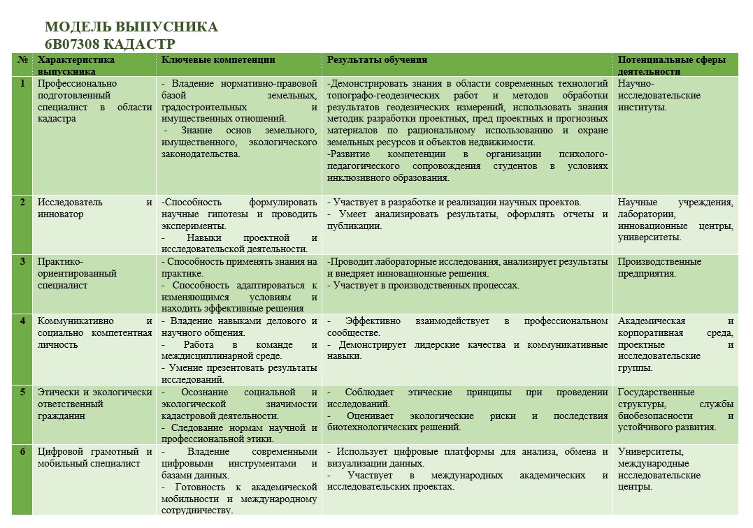
- Инженер по кадастру,
- геодезист,
- картограф,
- инженер по кадастровому учету,
инспектор в предприятиях, организациях и учреждениях системы Комитета по управлению земельными ресурсами.
Управление и организация земельно-кадастровых и работ по оценке земли и других объектов недвижимости, землеустроительных, геодезических, и кадастровых работ, государственного контроля использования и охраны земель, изыскательских и обследовательских работ; регистрация и учет земель, отвод земельных участков и оформление правоудостоверяющих документов, осуществление мониторинга земель всех категорий, ведение операций с землей и недвижимостью.
-НАО «Госкорпорация «Правительство для граждан»;
-Комитет по управлению земельными ресурсами Министерства сельского хозяйства РК;
-РГП «Градостроительный кадастр» Министерства по инвестициям и развитию РК;
-ГУ «Управление архитектуры, градостроительства и земельных отношений»;
-ГУ «Управление контроля и качества городской среды»;
-НК «Қазақстан Ғарыш сапары»;
-Комитет лесного хозяйства Министерства сельского хозяйства РК;
-Комитет по водным ресурсам Министерства сельского хозяйства РК;
-Оценочные и риэлтерские компании;
-Генеральный план развития города (района);
-Отделы оценки в банках второго уровня;
-Центры обслуживания населения (ЦОН) и др.
Геодезические и топографические съемки земель; фотограмметрические работы и картографирование земель с использованием ГИС и цифровых технологий;
ведение государственного земельного кадастра и АИС ГЗК;
ведение мониторинга, государственного контроля использования и охраны земель;
проведение земельно-оценочных работ.
1. Оценочные:
апробация автоматизированных систем проектирования, обработки кадастровой и другой информации, их анализ
управление и организация процессов ведения геодезических, землеустроительных и кадастровых работ, государственного контроля использования и охраны земель, мониторинговых и других изыскательских и обследовательских работ.
2. Конструктивные:
организация и ведение геодезических, топографических съемок, корректировок планово-картографического материала, регистрации и учета земель, отвод земельных участков и оформление правоудостоверяющих документов, ведение государственного контроля за использованием и охраной сельскохозяйственных земель и земель населенных пунктов, осуществление мониторинга земель всех категорий, ведение операций с землей и недвижимостью.
3. Информационно-технологические:
использование информационных технологий, моделирования и современной техники при создании кадастровых карт и формирование кадастровых информационных систем, составление земельных балансов, земельно-кадастровых документов и карт, проектов мелиорации и улучшения земель; ведение научных исследований и изысканий по земельному кадастру, мониторингу земель, оценке земель.
Самостоятельно решать вопросы в области кадастра, оценки земель и недвижимости, регистрации прав на недвижимое имущество, мониторинга земель, регулирования земельных отношений; участие в технической инвентаризации объектов недвижимости и межевании земель; участие в проведении кадастровой оценки земельных участков и объектов недвижимости; в эффективном использовании знаний в различных ситуациях по вопросам использования земли, разрешения земельных споров; выполнению земельно‐кадастровых работ.


